COOPER NUCLEAR STATION PLANNING AND EVACUATION
The Cooper Nuclear Station, owned and operated by the Nebraska Public Power District, is located just south of Brownville, Nebraska on the Missouri River. The Brownville Recreational area, the Indian Cave State Park, and Steamboat Trace Trail are within the 10 mile EPZ (emergency planning zone).
The plume emergency planning zone (EPZ) is a ten-mile radius around the plant and is shared by the states of Missouri and Nebraska. Nebraska counties falling within the plume EPZ are Nemaha and Richardson counties. The ingestion EPZ is a 50-mile radius around the plant. Nebraska counties falling within the ingestion EPZ are Cass, Gage, Johnson, Lancaster, Nemaha, Pawnee, Otoe, Richardson, and Sarpy counties.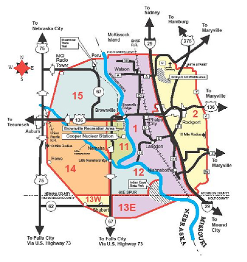
In the event of an evacuation, those needing shelter would go to either the Falls City High School at 1400 Fulton Street in Falls City or the Nebraska City Middle School at 1st Corso and 9th Street in Nebraska City. A map of evacuation routes may be found in the Emergency Planning Brochure located inside the Cooper Nuclear Station yearly calendar (or as a link from this website). The American Red Cross provides support for evacuees in shelters in both Falls City and Nebraska City.
Should an emergency occur at the Cooper Nuclear Station, sirens will sound a steady tone for three to five minutes which will alert residents in the EPZ to turn on their radio or television set for information. Rural residents may also be alerted when their Emergency Alert Radio (EAS) tone-activated radio automatically turns on.
There are four levels of emergency classification levels. These include: Unusual Events, Alert, Site Area Emergency and General Emergency.
Questions may be directed to your local County Emergency Management Director (Nemaha, Otoe, and Richardson Counties) or contact NEMA - Technical Hazards at (402) 471-7421.
Nebraska Sub-Area Evacuation Routes
Nebraska Sub-Areas: 11 | 12 | 13E | 13W | 14 | 15
| Area | Description | Evacuation Routes and Reception Centers |
|---|---|---|
| 11 | From the Brownville bridge on U.S. Highway 136, south along the west bank of the Missouri River to the confluence of the Little Nemaha River, northwest along the north bank of the Little Nemaha River to U.S. Highway 67, then north to Nemaha, west 1/2 mile from Nemaha to the first north/south county road, then north on the county road to U.S. Highway 136 to the Brownville Bridge. This area includes the villages of Brownville and Nemaha, the Brownville Recreation Area and Steamboat Trace Trail. | To Falls City…U.S. Highway 75 or Nebraska Highway 67 south to U.S. Highway 73 south to Falls City. The Reception Center in Falls City is the High School at 1400 Fulton Street. |
| 12 | From the Little Nemaha River bridge on Nebraska Highway 67 along the southern bank of the Little Nemaha River to the Missouri River confluence, along the Missouri River east and south to the northern boundary of Indian Cave State Park. Then west and south along the boundary of Indian Cave State Park to the intersection of the Richardson and Nemaha County Line, then west to Nebraska Highway 67, then north on Nebraska 67 miles to the Little Nemaha River bridge. | To Falls City…U.S. Highway 75 or Nebraska Highway 67 south to U.S. Highway 73 south to Falls City. The Reception Center in Falls City is the High School at 1400 Fulton Street. |
| 13E | From the intersection of the Richardson and Nemaha County Line and Nebraska Highway 67 east to, and including all of Indian Cave State Park, then south along the Missouri River (east side of park) to the southeast corner of the park. From the southeast corner of the park and the river, go southwest to a point three miles east and one mile south of the intersection of Nebraska Highways 62 & 67, then west three miles to Highway 67, north to the Richardson and Nemaha County Line on Highway 67. | To Falls City…U.S. Highway 75 or Nebraska Highway 67 south to U.S. Highway 73 south to Falls City. The Reception Center in Falls City is the High School at 1400 Fulton Street. |
| 13W | From the intersection of Richardson and Nemaha Counties and Nebraska Highway 67 south three miles on Highway 67, then northwest to the Stella Saddle Club, and continuing to the Nemaha/Richardson county line, one mile northwest of the Stella Saddle Club, then east to the Richardson and Nemaha county line at Highway 67. This area includes the village of Shubert. | To Falls City…U.S. Highway 75 or Nebraska Highway 67 south to U.S. Highway 73 south to Falls City. The Reception Center in Falls City is the High School at 1400 Fulton Street. |
| 14 | From the Union Pacific Railroad tracks east of Auburn, east on U.S. Highway 136 to 1/2 mile west of the intersection of U.S. Highway 136 & Nebraska Highway 67, then south to Nemaha, continuing south along Nebraska Highway 67 to the intersection of Nebraska Highway 67 and the Richardson and Nemaha County line, then west along the Richard and Nemaha County line to the intersection of the county line and 3.5 miles east of U.S. Highway 75, then northwest, to the Union Pacific Railroad tracks and U. S. Highway 136. This includes the village of Howe. | To Falls City…U.S. Highway 75 or Nebraska Highway 67 south to U.S. Highway 73 south to Falls City. The Reception Center in Falls City is the High School at 1400 Fulton Street. |
| 15 | From the Union Pacific Railroad tracks east of Auburn, northwest to the MCI Radio tower (which is two miles east of U.S. Highway 75 on Nebraska Highway 67), from the MCI tower east northeast to include Peru, then east to the Missouri River, then south along the west bank of the Missouri River to the river bridge at Brownville, then west on U.S. Highway 136 to the Union Pacific Railroad tracks east of Auburn. This area includes Steamboat Trace Trail. | To Nebraska City…U.S. Highway 136 west to U.S. Highway 75 north to Nebraska City… or proceed north & west on Nebraska Highway 67 to U.S. Highway 75 then north to Nebraska City and the Reception Center at the Nebraska City Middle School at 909 1st Corso. |